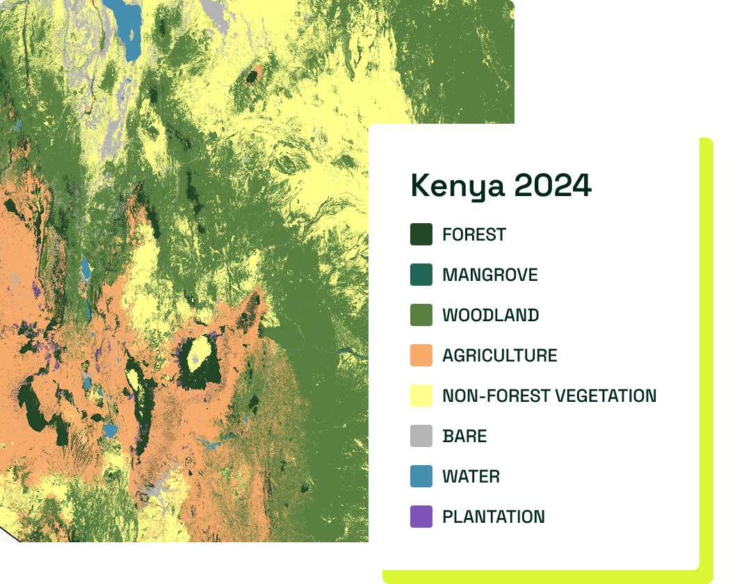
Customize Consent Preferences

We use cookies to help you navigate efficiently and perform certain functions. You will find detailed information about all cookies under each consent category below.

The cookies that are categorized as "Necessary" are stored on your browser as they are essential for enabling the basic functionalities of the site. ... 

Always Active

Necessary cookies are required to enable the basic features of this site, such as providing secure log-in or adjusting your consent preferences. These cookies do not store any personally identifiable data.

No cookies to display.

Functional cookies help perform certain functionalities like sharing the content of the website on social media platforms, collecting feedback, and other third-party features.

No cookies to display.

Analytical cookies are used to understand how visitors interact with the website. These cookies help provide information on metrics such as the number of visitors, bounce rate, traffic source, etc.

No cookies to display.

Performance cookies are used to understand and analyze the key performance indexes of the website which helps in delivering a better user experience for the visitors.

No cookies to display.

Advertisement cookies are used to provide visitors with customized advertisements based on the pages you visited previously and to analyze the effectiveness of the ad campaigns.

No cookies to display.

Back

Our Publicly Available Work

We have worked on projects in more than 15 countries and mapped landcover equivalent to the size of Europe across the globe. Much of our work is covered by non-disclosure agreements which preclude us from publishing our involvement and contribution. Whilst we cannot discuss work performed under confidentiality agreements, we have described below a selection of projects that demonstrate our capacity.

Winner of Shell’s Gamechanger Programme

Rebrota Project

We produced detailed landcover maps using social media-images with data from earth-orbiting satellites. Our Rebrota programme was the winning proposal out of the 73 submitted applications worldwide. We used machine-learning to derive meaning from geolocated images uploaded onto social media platforms from people trekking in the Cerrado. With our machine-learning approach we mapped the entire Cerrado – an area as big as France, Spain, Germany, Italy and the UK put together – better supporting nature-based solutions.

Winrock International

Deforestation & forest degradation mapping in Cambodia

We have a contract with US Company Winrock International to map deforestation and small-scale degradation within Prey Lang Forest, Cambodia. No other satellite technology could see the changes we see as the area is cloudy and much tree clearance hidden under the canopy.

Green Gold Loreto

Above ground carbon stock changes in Peru

Using our CarbonMapper technology, we are monitoring annual carbon stock changes in above ground biomass of trees and vegetation. This analysis is being undertaken through per-pixel biomass calculations for a landmass of 250,000 hectares in North East Peru. These maps will be accurately created and compared to previous calculations to determine the change in carbon stocks in this area. We are also advising local teams in the development of forest plot strategy including plot placement, measurement and protocol.

Nicola Sturgeon on Space Intelligence at #DataSummit21

Mapping Scotland’s Landcover

Using HabitatMapper™, we created 20 habitat classes to map Scotland’s landcover. This enabled NatureScot to create accounting for Scotland’s natural capital. HabitatMapper™ is being used with the Scottish Government to track change in Scotland’s landcover.

Our Clients

Our Partners

Grant Funding