Space Intelligence’s land cover data is now available in Lens

Space Intelligence is delighted to announce that our land cover and land cover change data is now available for easy analysis, monitoring and reporting in Lens!
What is Lens?
Developed by Upstream Tech, Lens empowers users to track landscape changes, visualise trends, and automate reporting without requiring technical expertise. By making our audit-grade data accessible through Lens, we are democratising high-quality geospatial data, making monitoring and reporting easier than ever.
Monitoring and analysis with Lens
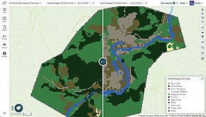
Lens consolidates satellite and aerial imagery from public and commercial sources, including HabitatMapper™ by Space Intelligence.
The platform offers actionable insights for monitoring, reporting, and verification (MRV) for carbon project managers, due diligence teams, carbon credit buyers, and conservation organisations.

Now, our entire land cover catalogue – covering 45+ countries with 10m/20m resolution across various time points – is accessible in Lens.
Lens removes the technical barrier to geospatial data, allowing any user, regardless of technical experience, to:
- Streamline early project screening & diligence
- Access Space Intelligence’s audit-grade datasets for your your project areas
- Set up change-detection alerts so the platform can passively monitor your properties for things like increase in Burn, dips in Vegetation, etc
- Generate reports in one click to easily share out observations
Get started
Explore available geographies and pricing, or email the Upstream team at [email protected] to request data for your areas of interest.
Tag:announcement, land cover, mrv

